Flood watch in effect for Southern New England. Winter Storm Warning for Northern VT and Northern NH and into most of Maine.
Today: Rain, heavy at times. Transitioning to snow north later in the afternoon north. Highs in the 50s south, 40s north with temperatures falling throughout the day.
Tonight: Rain continues, heavy at times, snow pushes further south across Northern New England. Accumulations of 6-12 inches overnight. Lows in the 20s north, 40s south.
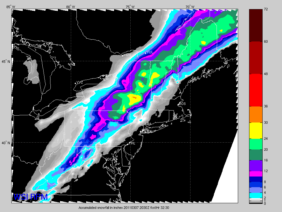
Tomorrow: Rain and snow comes to an end in the afternoon. Daytime highs will occur in the morning with temperatures falling or holding steady through the day, 40s south, upper 20s to low 30s north. Total accumulations of 20-30 inches, see image below.
Tuesday: Mostly sunny, cooler, highs upper 30s to near 40 south, 20s and 30s north.
Discussion: A large and complex low pressure system is approaching the region. This will bring heavy rain and heavy snow later today and tonight. It is already raining in some places, particularly in Central and Northern New England. The rain will overspread all areas this afternoon and become heavy at times. The center of the low pressure system will essentially pass directly over New England tomorrow and it get closer, colder air will start moving in. This will change over the precipitation to a wintry mix and then to all snow. This will start in northwestern New England first and then push southeastward. Eventually the snow spread all the way down into Southern VT, Western MA and Southwestern NH. There is going to be significant accumulations with this storm in Northern and Central New England, as much as 20 to 30 inches. There is so much moisture available and with the cold air coming in, its going to create a lot of heavy, wet snow. I'll include a forecast snow total image below, pulled directly from a forecast model. Unfortunately the complexity of the forecasted amounts is too difficult to depict using MS Paint.
Total liquid equivalent amounts will range from 1.5 to 4 inches. That is a lot of water and as a result, flood watches are in effect for places that are going to see strictly rain, Southern New England. Low lying areas and where there is poor drainage, I expect to see some flooding. Also, some of the smaller streams and rivers might spill their banks. The worst of the flooding will likely occur on Monday.
Beyond tomorrow, conditions will quiet down for a few days with seasonable temperatures. Our next storm system will affect the region late in the week and looks like mainly a rain event right now.
Here is the forecast snow totals:
No comments:
Post a Comment