Heavy rain is on its way for today, followed by a quiet and mild weekend.
Today: Rain, heavy at times between 10 AM and 4 PM. Highs in the low to mid 50s south, 40s north.
Tonight: Slight chance of a rain or snow shower, becoming partly cloudy, lows near 30 south, 20s north.
Tomorrow: Partial sunshine, slight chance of a snow shower in the morning, highs low to mid 50s south, upper 40s to near 50 north.
Tomorrow night: Partly cloudy, lows in the 30s south, 20s north.
Sunday: Mainly sunny, highs in the upper 40s south, low 40s north.
Discussion: The main area of precipitation will rotate through New England today, it is already affecting Western New England. It won't be long before Eastern Southern New England sees the steady moderate to heavy rain. There is a slight chance a few rumbles of thunder might be heard in the heavier downpours. I'm expecting rainfall amounts between 0.5" and 1.5" of rain today. Flooding still remains a concern, but this threat should be isolated as we shouldn't see widespread rain amounts over 1".
Once the rain moves out later today our skies should clear a bit overnight. There is still a slight chance of a stray shower or snow shower overnight, especially in central and northern New England. Temperatures will drop off to near or below freezing tonight. Behind this low pressure system we won't see a significant drop off in temperatures. They will gradually go down through the weekend into the start of the work week.
I'll have a bit more later, including some info on the Tsunami warnings for the West Coast of North America. I'm currently watching what is happening in Hawaii right now.
Thanks for reading!
-Jon K.
Showing posts with label flooding concerns. Show all posts
Showing posts with label flooding concerns. Show all posts
Friday, March 11, 2011
Thursday, March 10, 2011
Tricky forecast
The storm that currently is affecting parts of New England has been tricky to figure out as it has changed again, probably for the better.
Today: Rain/snow showers possible, rain south, snow north. Looks like any snow won't last long or be as heavy, 1-3 inches possible in far northern New England. Highs near 40 south, mid 30s north.
Tonight: Rain at times south, changing from snow to rain north. Temperatures rising a few degrees overnight.
Tomorrow: Periods of rain, maybe a few rumbles of thunder in the afternoon, highs in mid 50s south, upper 40s to near 50 north.
Tomorrow night: Rain ends, maybe mixing with snow north, lows in the mid and upper 30s south, upper 20s to near 30 north.
Saturday: Mostly cloudy, slight chance of a snow shower in the morning, then slight chance of rain showers in the afternoon. Highs in the upper 40s to low 50s south, in the 40s north.
Discussion:
Looking at the radar this morning, you would think that it should be precipitating everywhere. However, this is not the case as there is a lot of dry air aloft that is evaporating the precipitation before it reaches the ground. Eventually the dry layer aloft will become moist, allowing that precipitation to reach the ground. This will happen when the second wave of precipitation arrives late today and tonight. By this time, all of southern New England will be warm enough to support rain. The transition to all rain may hold off until around sunrise on Friday morning for Northern New England, particularly Northern New Hampshire and Maine.
I expect the rain to be more scattered and showery in nature tonight and tomorrow morning with steadier rain moving in on Friday afternoon as the cold front pushes through the region. I wouldn't be surprised to see a few lightning strikes and hear a few rumbles of thunder in some of the heavier rain. There are going to be a few spots that pick up over an inch of rain in a short period of time, but this looks pretty isolated. The isolated nature of the heavier rain should reduce the flooding threat slightly. However, all the rivers and streams of New England and still swollen, so any additional rain will only make matters worse. So once again, be ready for some flooding late on Friday into Saturday.
Looking into this weekend, conditions should be generally dry, save for a few scattered showers on Saturday. Temperatures will drop off late in the weekend as colder air moves in behind the storm system currently closing in on the region. Don't worry though, the chill won't be frigid and won't last long. Our winds will change around to a more southerly direction early next week and then the warm up will begin again. By the end of next week I expect it to be very mild here in New England.
I'll update as necessary today, thanks for reading!
-Jon K.
Monday, March 7, 2011
Storm ending, flooding still a concern
Even though the storm is pulling away, flooding will remain possible into Wednesday.
If you are interested in seeing snow totals so far, click here, its an interactive map that will let you move around and zoom in and out. The amounts are impressive, especially in Upstate NY.
Also, if you want to see current river levels and forecasts, click here for Southern New England and here for Central and Northern New England. You could click on the map to view the rivers levels and forecasts.
Flood Watches and Warnings are currently in effect for several locations in Southern New England. Winter Storm Warnings continue into the middle of day.
Today: Rain/snow/sleet comes to an end. Temperatures remain steady or dropping slowing through the day. Highs mid 20s north, mid 30s south.
Tonight: Decreasing clouds, cold, lows near 0 north, teens to low 20s south.
Tomorrow: Lots of sunshine, highs in the low to mid 40s south, upper 20s to low 30s north.
Wednesday: Mostly sunny, highs upper 30s south, upper 20s to near 30 north.
Discussion:
The low pressure system that brought all the unsettled weather last night is continuing to affect New England, particularly in Central and Northern New England. Snow and sleet is still falling in VT, NH and Maine. The precipitation will hang on the longest in Maine, coming to an end late this afternoon. Look for the snow to taper off in VT by Noon and mid afternoon in NH. Additional accumulations are expected on the order of 3-6 inches in VT and NH, with another 6-10 inches in Maine with isolated higher amounts.
If you checked out the link above related to river forecasts, you would have seen that the flooding threat will continue into Wednesday. It wasn't just the rain last night that is the main cause of flooding, it will be the runoff from melting snow that is still making it's way into the rivers of New England. This is a slower process. What the rain did do, is raise the river levels slightly and then when you add the runoff, the river levels are expected to shoot up higher. So if you live near a river, keep a close eye on it and prepare as best you can. Chances are, you've dealt with this before and know how to prepare.
As the storm pulls away tonight, the cloudiness will go with it and our skies will clear. This will allow temperatures to fall off even more as well. Places that received new snowfall will see the coldest overnight readings, some places getting down to near 0. High pressure will start to build in tomorrow and will keep our weather quiet into the day on Thursday. Temperatures will be a bit cooler during the middle of the week, then gradually warm up again.
The warm up begins ahead of another low pressure system that should pass off to our west late in the week. This looks like it will be rain for nearly everyone this time, but this could obviously could change. I'll have to keep an eye on this, but the storm we are currently getting looked like rain for everyone at first as well, that definitely wasn't the case.
That's all for now. Post any questions you might have below in the comments section, I'll answer as I have time today. Thanks for reading!
-Jon K.
Sunday, March 6, 2011
Rain and snow cometh
An extreme moist storm system is already affecting New England and will continue to into the day on Monday.
Flood watch in effect for Southern New England. Winter Storm Warning for Northern VT and Northern NH and into most of Maine.
Today: Rain, heavy at times. Transitioning to snow north later in the afternoon north. Highs in the 50s south, 40s north with temperatures falling throughout the day.
Tonight: Rain continues, heavy at times, snow pushes further south across Northern New England. Accumulations of 6-12 inches overnight. Lows in the 20s north, 40s south.
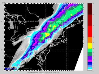
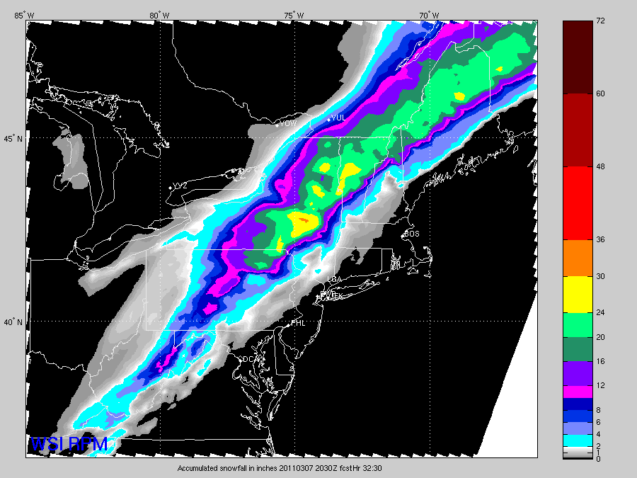
Tomorrow: Rain and snow comes to an end in the afternoon. Daytime highs will occur in the morning with temperatures falling or holding steady through the day, 40s south, upper 20s to low 30s north. Total accumulations of 20-30 inches, see image below.
Tuesday: Mostly sunny, cooler, highs upper 30s to near 40 south, 20s and 30s north.
Discussion: A large and complex low pressure system is approaching the region. This will bring heavy rain and heavy snow later today and tonight. It is already raining in some places, particularly in Central and Northern New England. The rain will overspread all areas this afternoon and become heavy at times. The center of the low pressure system will essentially pass directly over New England tomorrow and it get closer, colder air will start moving in. This will change over the precipitation to a wintry mix and then to all snow. This will start in northwestern New England first and then push southeastward. Eventually the snow spread all the way down into Southern VT, Western MA and Southwestern NH. There is going to be significant accumulations with this storm in Northern and Central New England, as much as 20 to 30 inches. There is so much moisture available and with the cold air coming in, its going to create a lot of heavy, wet snow. I'll include a forecast snow total image below, pulled directly from a forecast model. Unfortunately the complexity of the forecasted amounts is too difficult to depict using MS Paint.
Total liquid equivalent amounts will range from 1.5 to 4 inches. That is a lot of water and as a result, flood watches are in effect for places that are going to see strictly rain, Southern New England. Low lying areas and where there is poor drainage, I expect to see some flooding. Also, some of the smaller streams and rivers might spill their banks. The worst of the flooding will likely occur on Monday.
Beyond tomorrow, conditions will quiet down for a few days with seasonable temperatures. Our next storm system will affect the region late in the week and looks like mainly a rain event right now.
Here is the forecast snow totals:
Flood watch in effect for Southern New England. Winter Storm Warning for Northern VT and Northern NH and into most of Maine.
Today: Rain, heavy at times. Transitioning to snow north later in the afternoon north. Highs in the 50s south, 40s north with temperatures falling throughout the day.
Tonight: Rain continues, heavy at times, snow pushes further south across Northern New England. Accumulations of 6-12 inches overnight. Lows in the 20s north, 40s south.
Tomorrow: Rain and snow comes to an end in the afternoon. Daytime highs will occur in the morning with temperatures falling or holding steady through the day, 40s south, upper 20s to low 30s north. Total accumulations of 20-30 inches, see image below.
Tuesday: Mostly sunny, cooler, highs upper 30s to near 40 south, 20s and 30s north.
Discussion: A large and complex low pressure system is approaching the region. This will bring heavy rain and heavy snow later today and tonight. It is already raining in some places, particularly in Central and Northern New England. The rain will overspread all areas this afternoon and become heavy at times. The center of the low pressure system will essentially pass directly over New England tomorrow and it get closer, colder air will start moving in. This will change over the precipitation to a wintry mix and then to all snow. This will start in northwestern New England first and then push southeastward. Eventually the snow spread all the way down into Southern VT, Western MA and Southwestern NH. There is going to be significant accumulations with this storm in Northern and Central New England, as much as 20 to 30 inches. There is so much moisture available and with the cold air coming in, its going to create a lot of heavy, wet snow. I'll include a forecast snow total image below, pulled directly from a forecast model. Unfortunately the complexity of the forecasted amounts is too difficult to depict using MS Paint.
Total liquid equivalent amounts will range from 1.5 to 4 inches. That is a lot of water and as a result, flood watches are in effect for places that are going to see strictly rain, Southern New England. Low lying areas and where there is poor drainage, I expect to see some flooding. Also, some of the smaller streams and rivers might spill their banks. The worst of the flooding will likely occur on Monday.
Beyond tomorrow, conditions will quiet down for a few days with seasonable temperatures. Our next storm system will affect the region late in the week and looks like mainly a rain event right now.
Here is the forecast snow totals:
Friday, March 4, 2011
Here comes the "warmth"
A chilly start this morning, just a quick check shows a few places that got down to -20. However, the warm air is already making its push in as those places have already climbed above 0 degrees. That's quite a swing in a just few hours.
Anyway, high pressure will stay in control today as it slides offshore. This will turn our winds around to the southwest, helping to usher in the warmer air. Temperatures will moderate nicely today, getting close to 30 in Northern and Central New England, climbing well into the 30s in Southern New England. Look for plenty of sunshine for most of the day with a few high clouds moving in throughout the day.
This weekend will prove to be interesting. A large, complex low pressure system is organizing in the Central United States. This will tap into moisture from the Gulf of Mexico to bring quite a bit of rain to the Ohio Valley, Upstate NY and New England. Flood watches have already been posted for some spots in Ohio, PA and Western NY and I would imagine more watches will be issued today for Central NY into the Adirondacks and Mohawk Valley of NY.
This storm system will be moving very slowly as the upper level winds will be nearly parallel to the surface front. This means there won't be much west to east push of the storm system. It won't be until Sunday that a piece of energy moves out of Western Canada that will give this storm system a push to move it into New England. So, given the slow movement, New England should stay generally dry until later in the day on Sunday. We should have a decent amount of sunshine on Saturday, which should kick temperatures well into the 40s for most locations, wouldn't be surprised to see a few spots in Southern New England reach 50 degrees.
Temperatures on Sunday should be a bit warmer, especially if we see a few hours of sunshine. That will be the big question, how much sun will we see, as that storm will be on our door step. Regardless, Southern New England should easily widespread 50s and 40s elsewhere. If we see more sun that I currently expect, 60s may be possible for SNE. The rain should hold off until the late afternoon, maybe even until after the sun goes down. The location of where the heaviest rain will fall still remains a mystery. This morning it appears that the heaviest will fall in Central and Northern New England. Forecast rainfall totals still look impressive with a large area of 2+ inches of rain. This combined with the amount of liquid remaining in the snow pack will keep flooding possibilities high. Smaller rivers and streams are at the highest risk because they are likely frozen right now and as the ice breaks up, ice dams may develop.
The majority of the precipitation should fall during the day on Monday, with the possibility of some mixing in Northern New England as the cold air starts to make a return. Southern and Central New England should see strictly rain from this system.
Beyond Monday we will see temperatures return to seasonable levels, with another warm up throughout the week and another rain event next Friday.
I'll have more throughout the weekend on this storm and the potential for flooding.
Thanks for reading!
-Jon K.
Thursday, March 3, 2011
Cold now, milder air enroute
A frigid start this morning followed by an even colder morning coming up tomorrow.
High pressure is in full control of New England this morning and this will remain the case through the day tomorrow. Temperatures this morning could have gotten colder, but there was enough of a breeze to keep the air mixed and temperatures up slightly. The same wind is resulting in below zero wind chills however. Daytime highs will be in the teens and low 20s and with the wind, wind chills values will remain very cold. Be careful if you are going to be outdoors for an extended period of time today.
The winds will die down tonight, this combined with the same cold air mass overhead will cause temperatures to plummet tonight. Looking at some of the temperature guidance for tomorrow morning, it looks like some spots will fall way, way below zero. This will likely happen in the typical cold spots of Northern and Central New England, especially in valleys. For example, the low temperature forecast for Berlin, NH is -30 for Friday morning. Needless to say, be prepared for a very cold start. We will have another day of sunshine, for the most part, a few clouds will likely move in throughout the day. Temperatures will climb to the upper 20s and low 30s in the afternoon.
The warm air will really start moving in on Friday night, starting above our heads and then at the surface during the day on Saturday. The milder conditions are being forced in by a large area of low pressure that is currently developing in the Central United States. As this system gets more organized, it will tap into moisture from the Gulf of Mexico. This will make this system very "wet" and will likely result in flooding for some locations east of the Mississippi River. We should stay dry here in New England until Sunday as the system will be moving very slowly. All the precipitation will be elongated along the low pressure system's cold front that will drape from the center of the low down toward the Gulf Coast. Eventually the low will pass through the Great Lakes and then well off to our north and west. This will keep the Northeastern US on the warm side of the storm and provide rain for almost everyone.
Temperatures will shoot up nicely on Saturday, reaching at least the 40s with a few 50s in Southern New England. Look it to be a few degrees warmer on Sunday than Saturday, with rain moving in during the afternoon. The model runs from last night and this morning aren't showing as much rain as they were yesterday morning and then ones that weren't showing a lot of rain, now are. I still expect a good deal of precipitation to fall here in New England, which will more than likely result in some flooding problems, especially when you combine it with the warmth we will have.
Stay tuned! Thanks for reading!
-Jon K.
Thursday, February 24, 2011
Complicated storm
We have one more pleasant day today, even if it did start off rather cold. We will see abundant sunshine through at least the first half of the day before some clouds develop. Temperatures should make it to 40 degrees in Southern New England and 30s for Central and Northern NE. The clouds that will start to move in will be in response to the approaching storm system set to arrive on Friday morning.
After reviewing some computer guidance this morning, the system appears to be moving a bit slower than previously forecast. Instead of the precipitation getting started around 3 AM, it will probably start around sunrise now, closer to 7 AM. Precipitation type is proving difficult to forecast, as surface temperatures in many locations will get close to or below freezing for a time on Friday morning. I will provide 2 maps today, one indicating precipitation type and the other indicating snow totals, much easier to show you rather than describe it.
 Green is all rain, the pinkish color is where there will be a period of a mix and then the light blue is all snow. Below is snow total map.
 As you can see VT and most of NH are going do well in terms of snow with this storm. I left the accumulation range pretty wide as there is going to be banding in spots which will give some areas high amounts. It would be far too difficult to pin those locations down. The purple area will see a few hours of sleet and freezing rain before changing over to mainly rain. Fortunately this won't produce much accumulation, but will make the road messy. The green area should be mostly rain, with some northern areas in this zone seeing some mixing, but hardly any accumulation.
There is going to be quite a bit of liquid associated with this storm and there is going to be flooding problems. The flooding problems will obviously be in the locations that have mostly rain. Eastern MA and RI may have to deal with the worst of any flooding that occurs. This will be caused by ice daming of small tributaries and street drains that are still clogged with ice. Just be mindful of this tomorrow and avoid driving across water covered roadways.
Beyond Friday, we'll see another light snow on Sunday morning, followed by a gradual warm up leading to what looks like storm on Tuesday that provides mainly rain. More to come on this, but I think you have plenty to chew on for now. :-)
Thanks for reading and post any questions in the comments area below!
-Jon K.
After reviewing some computer guidance this morning, the system appears to be moving a bit slower than previously forecast. Instead of the precipitation getting started around 3 AM, it will probably start around sunrise now, closer to 7 AM. Precipitation type is proving difficult to forecast, as surface temperatures in many locations will get close to or below freezing for a time on Friday morning. I will provide 2 maps today, one indicating precipitation type and the other indicating snow totals, much easier to show you rather than describe it.


There is going to be quite a bit of liquid associated with this storm and there is going to be flooding problems. The flooding problems will obviously be in the locations that have mostly rain. Eastern MA and RI may have to deal with the worst of any flooding that occurs. This will be caused by ice daming of small tributaries and street drains that are still clogged with ice. Just be mindful of this tomorrow and avoid driving across water covered roadways.
Beyond Friday, we'll see another light snow on Sunday morning, followed by a gradual warm up leading to what looks like storm on Tuesday that provides mainly rain. More to come on this, but I think you have plenty to chew on for now. :-)
Thanks for reading and post any questions in the comments area below!
-Jon K.
Tuesday, February 22, 2011
High pressure in control
As the title states, high pressure is in command and this will keep our weather quiet through the day on Thursday. Unfortunately, it will be chilly today and breezy at times. Wind chill values will be quite cold today. Bright sunshine is expected however, so if you are in direct sunlight, sheltered from the wind, the sun will feel warm. Look for high temperatures only in the 20s today.
Tomorrow and Thursday, tempeatures will warm a few degrees each day, we'll hit the mid to upper 30s tomorrow(more melting, yay!) and then into the 40s in Southern New England on Thursday, probably still in the 30s for Central and Northern New England. Skies should remain mainly sunny right through sundown on Thursday evening. Our attention then turns to a storm system approaching from the Appalachains.
The forecast models, after several runs showing a similar solution are starting to deviate from each other now. This of course makes it very difficult to forecast what is going to happen. However, the one model that is showing it colder, hasn't been doing a very good job this winter. The model that is showing a warmer solution has been pretty solid. I'm going hedge toward that warmer solution for now. I still expect much of New England to get a period of wintry precipitation. The further south you are, the shorter this period will be. Places in Northern New England may get a significant ice event from this system.
On the other side of the spectrum, if the colder situation develops, we'll see mainly snow, but the majority of the precipitation will stay south of New England. It would be a plowable snow in Northern MA into VT and NH, but not a crippling event.
Now if the warmer solution develops, as I have stated for the last few days, flooding will be concern, particularly in Southeastern MA and RI. Time will tell and I'm monitoring closely.
We probably will see a light snow on Sunday as a weak disturbance pass through. Temperatures after this system passes through on Friday will drop off to chilly again and probably will remain chilly until the beginning of next week.
Stay tuned and tell your friends about this blog! Thanks for reading!
-Jon K
Friday, February 11, 2011
Come on melting!
Not too much to discuss this morning, that's a good thing. The overall weather pattern here in the Northeast will remain relatively quiet through the weekend. There will be the chance of a few rain or snow showers, but nothing significant.
We'll see a decent amount of sunshine today, there may be some cloudiness that develops as we head into the afternoon. Temperatures will still be on the chilly side, generally in the 20s with a few spots hitting the low 30s, mainly in southern areas.
Saturday will begin with a bit of cloudiness and maybe a few flurries or snow showers. Most of this activity will be centered in the higher elevations of the New England. Other than that, temperatures will be a bit milder, low to mid 30s in Southern New England with upper 20s in Northern New England. Sunday will also bring the slight chance of some snow showers, especially late in the day. There may be a few rain drops mixed in with the snow at times. This activity will be quite isolated. Look for temperatures to be a couple degrees higher than Saturday's highs.
Monday will likely be the best chance for a widespread precipitation event. Temperatures are going to be near or above freezing, so there might be some mixing. For the most part, this will be a heavy wet snow for much of New England. Accumulations still look to be on the low side, I'll provide more information on this later in the weekend. The path of this low has been jumping around a little bit in the forecast models, I'll wait for them to come to more of a consensus before I get too detailed.
The best news will be the temperature moderation that will come late next week and next weekend. It will be exactly what we need, and deserve. The whole atmospheric set up will flip for a few days bringing up southerly winds. This will force some warmer air to move in starting on Wednesday. Exactly how long this set up will last is still in question, but I expect it to stay mild through Saturday. During this time it also looks like it will be dry so we should see a good deal of melting. This crucial because in most places, there is 5+ inches of liquid sitting in the snow pack. If we were to get a warm rain, flooding would be a major concern. I know I keep harping on this, but if we have a March like we did last year, it's not going to be pretty for low lying areas and people near rivers and streams.
Thanks for reading!
-Jon K.
P.S. - I've added some share buttons to my blog, if you feel like someone else might like to get their weather from me, please share! Thanks!
Subscribe to:
Posts (Atom)